


A small selection of photographs taken through 2011 & 2012 showing the site prior to the commencement of work, archaeological excavations undertaken and artefacts found. For a more detailed view around the site please see our 360 Virtual Tour. Images taken by team members and Paul Hewitt of Battlefield Design. Our thanks to him for permission to reproduce them here.
18 Photos
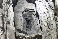
A selection of photographs taken underground in 2011 & 2012. Images taken by Terry Blackwood, Paul Hewitt of Battlefield Design and team members. Laser scans courtesy of Margaret and Tim Beach. Our thanks to all non-LBSG personnel for allowing us to reproduce the images here.
46 Photos
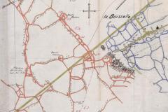
A small selection of La Boisselle trench and tunnelling maps from the National Archives. All images reproduced with their permission. More images to be added in due course.
4 Photos
2 Responses to Gallery